|
|
Finding
Fossils from Space
|
|
|
| Fossil
hunting takes a step into the future with the use of satellite data
to locate new fossil beds in the depths of the Gobi desert.
by John Weier
In 1993, after three summers of trudging across the barren rust
colored hills and deep sands of Mongolia's Gobi Desert, paleontologist
Mike Novacek and a team of researchers from the American Museum
of Natural History stumbled upon one of the richest fossil bed ever
found. The site, known as Ukhaa Tolgod, produced countless skeletons
of Velociraptors, several species of dinosaur embryo fossils, hard-to-find
fossils of the bird-like Mononykus, and skulls of Mesozoic mammals.
Since their big discovery, the researchers have traveled back
to the Gobi every summer to locate additional sites and to work
Ukhaa Tolgod. Despite the scientists’ experience and their earlier
success, locating potential fossil beds in the Gobi continues to
be a difficult task. The desert is vast and inhospitable with few
roads, harsh winds, and 100-degree (Fahrenheit) temperatures. Maps
are often inaccurate and trails are unmarked. Traipsing about looking
for these outcrops of reddish-brown sandstone where fossils are
often found requires an enormous amount of time and money.
Recently, in an effort to improve their chances, the museum researchers
have turned their attention to orbiting satellites. Using the images
these satellites produce of the Earth, Novacek and his team have
found a way to locate potential fossil beds before they even set
foot in the desert. Already their efforts uncovered one site last
year that produced several good specimens. In the future they hope
the images will not only cut down on the time they spend trekking
around the desert, but will also ensure that they never stop retrieving
remarkable specimens from the reddish-brown sandstone of the Gobi.
A Layered Past
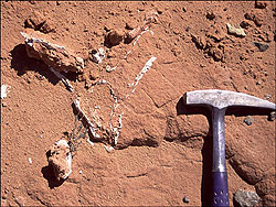
Courtesy
American Museum of Natural History
A
Protocertops skull from the late Cretaceous Period
|
Most of the fossils found in southern Mongolia represent animals
that lived some 80 million years ago in the late Cretaceous Period.
This was some 15 million years before the dinosaurs became extinct
and when the Velociraptor and the shield-headed Protoceratops roamed
the Earth. Paleontologists believe that the area now known as the
Gobi Desert, though primarily arid, also contained marshy areas
and ponds created by water run-off from the surrounding mountains.
Enough vegetation grew then to support a wide variety of dinosaurs,
lizards, and mammals (Loope et al., 1998).
These animals were trapped and buried in sediments in a number
of different ways during the late Cretaceous Period. Some were taken
by flash floods and were buried in flood plains. Some drowned in
lakes and were covered by silt. Still others were swallowed by sandstorms.
However, Novacek explains, the best-preserved fossils from Ukhaa
Tolgod came about as a result of collapsing sand dunes. Stable,
non-drifting sand dunes formed at and around the marshlands and
small ponds back then. "The dinosaurs would hunker down in these
dune fields and make their nests," said Novacek. Sometimes the dunes,
which were often many stories high, would become unstable. During
a heavy rain, the top layers of sand on the dune would slide down
its sides like an avalanche, catching dinosaurs unaware below and
covering them instantly as they were nesting, fighting, or collecting
food (Loope et al., 1998).
Over time, layers upon layers of sediments built up on top of these
dunes. Under the intense pressure of these additional strata, the
sand dunes turned to red sandstone and the bones within fossilized.
Millions of years later, continental uplift and erosion from water
and wind brought the fossils back to the surface. The climate in
this region became even more arid and sparsely vegetated, making
the fossils easy to find.
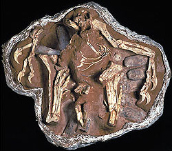
Courtesy
American Museum of Natural History
Dinosaurs
took care of their eggs in much the same way that birds do
today
|
Throughout the twentieth century, the red sandstone fossil beds
yielded the finest specimens of both late Cretaceous dinosaur and
mammal fossils in the world. In the 1920s while searching for human
fossil remains, Roy Andrews, a paleontologist at the American Museum
of Natural History, made the first big Gobi fossil discovery at
a locality known as the Flaming Cliffs. Here he found a fossilized
dinosaur nest as well as the first known skeletons of the infamous
Velociraptor. For the 60 years that followed, during the time that
Mongolia was under communist rule, researchers from Poland and Mongolia
trekked further into the desert, turning up, among other things,
a fossil of an Oviraptor in a fight to the death with a Protoceratops
(Webster, 1996).
The museum resumed its campaigns shortly after the Soviet Union
break up. Under the direction of Novacek, paleontologists uncovered
the greatest Gobi fossil beds to date around an area known as Ukhaa
Tolgod. "In this four-square-kilometer area we've found probably
as many specimens as have been found in the rest of the Gobi combined,"
says Novacek. He explains this site has not only given them great
specimens of fossils, but insights into the evolution of mammals
and how dinosaurs raised their young. An Oviraptor skeleton they
retrieved, for instance, shows that dinosaurs took care of their
eggs in much the same way that birds do today (Norell et al., 1995).
Well-preserved mammal skeletons dug up at the site have helped scientists
fill in branches of the evolutionary tree that perhaps led to our
existence.
Using Satellites to Unearth Fossils
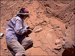
Courtesy
American Museum of Natural History
There
may be undiscovered sites all over the Gobi
|
Each year the winds and harsh winters of the Gobi peel away additional
layers of the red sandstone at Ukhaa Tolgod, exposing more fossils.
Every summer since 1993 researchers from the museum have traveled
back to the site, and they've continued to find remarkable specimens.
Despite their success, the paleontologists still believe that there
may be undiscovered sites just as good or even better in other parts
of the desert. So when Novacek and his team make their yearly pilgrimage,
they also take time to search for new fossil beds.
In general, the fossil-bearing red sandstone can be found in bluffs
and outcrops of eroded sedimentary rock. After the scientists locate
a potential site either by chance, by map, or by word of mouth,
they go to the area and poke around until they see enough evidence
of good fossils to start digging. "But locating these sites is often
very difficult," says Novacek. They are dispersed across the vast
desert and topographic and geologic maps of the Gobi aren't always
accurate. Novacek explains that driving around the Gobi looking
for sites that may or may not be there isn’t always the best idea.
Hundred-degree temperatures and sandstorms are common in the Gobi.
There are no gas stations or super markets along the way, so the
scientists have to bring large, unwieldy supply and gas trucks with
them. Once, while heading for a site they knew existed in the western
Gobi, the team had to go off road. They got mired in a large expanse
of sand and had to dig out the supply trucks and gas tanker twenty-one
times in one day. "I want to know exactly where we are going before
I take a column down there," said Novacek.
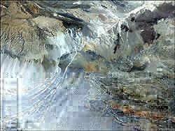
NASA
This
true color Landsat 5 image of the Gobi desert covers an area
between Ukhaa Tolgod and the Flaming Cliffs, two of Mongolia's
most famous fossil sites.
|
In order to find new sites and pinpoint ones they know exist, Novacek
and the other fossil hunters at the American Museum of Natural History
started using images of the Gobi Desert retrieved from the Landsat
5 satellite. This satellite, launched by NASA in 1984, moves in
a near-circular orbit very nearly from pole-to-pole around the Earth
and scans strip after strip of our spinning planet. A sensor array
onboard known as the Thematic Mapper has seven different types of
detectors, which acquire images of different wavelengths of reflected
sunlight or emitted thermal radiation from the surface of the Earth.
One light detector records only the blue light coming off the Earth
(band 1), another observes all the yellow-green light (band 2),
and still another picks up on thermal radiation (band 7). These
data are then beamed back to the planet's surface where they can
be made into detailed images of the Earth's surface. Scientists
can mix and match the various bands into a single image to highlight
various aspects of a section of land. For instance, vegetation in
a region can be highlighted by combining the blue, near-infrared,
and red bands of the Thematic Mapper data.
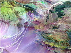
NASA
The
vegetation and different types of rock stand out more clearly
in this false color image of the Gobi
|
Unfortunately, there is no simple combination of bands that will
immediately pinpoint the fossil sites in the Gobi. Novacek explains
that the best they can do is combine blue, near-infrared, and thermal
radiation bands on the images of the desert. Together these bands
show the rock formations of the Gobi in the most detail. "We then
look for the outcrops with the right features and contours," he
says. After years of dealing with the geology of the Gobi, Novacek
and his team have developed a sense for what types of rock formations
will yield fossils and how to spot them on an image. Though there
are no hard and fast rules for identifying fossil-bearing outcrops,
he explains they are usually found at the base of the larger mountains
that run through the Gobi. These outcrops also contain layers of
sedimentary rock, and they are well-weathered, low-lying, and sparsely
vegetated. All of these aspects can be detected in the satellite
images.
So far, Novacek says they have had some success using these Landsat
images. Last year, in fact, they tracked down one such site northeast
of Ukhaa Tolgod and visited it on their yearly campaign. While it
was nothing like Ukhaa Tolgod, he says they did find a few well-preserved,
fossilized mammal skulls as well as some partial fossils of dinosaurs.
The find gives him confidence that in the future the maps will be
useful in tracking down both new sites as well as confirming sites
shown on the questionable older maps of the Gobi. "And more than
anything they will save us many days of driving across the desert,"
he says.
|
|
|