|
Farmers will soon have a new tool for getting
the most out of their fields. NASA's Aqua satellite will provide
crucial information about the water in the ground and the weather
on the horizon.
by Annie Strickler and Gil
Knier
Back in the old days, when farmers
wanted to find water in the ground, they hired a fellow called a
"dowser" who held a forked stick and went "water-witching." When
the forked stick "dowsed," or dipped toward the earth; supposedly
under the influence of hidden water- that's where water would be
found. Or so they said. But now NASA has a better way to find moisture
in the Earth.
Using data from NASA's Aqua
satellite - due to launch in December 2001 - scientists hope to
be able to map the moisture content of soils over most of the Earth's
surface. This information will also improve forecasts of potential
rainfall and other meteorological factors such as winds, temperature
and humidity. Better knowledge of water and weather should be a
boon to agriculture.
"What this improved information on current
soil moisture means for farmers is that we can improve long range
weather forecasting and consequently improve forecasts of crop yields,"
explains Bill Crosson, a scientist with the Universities Space Research
Association (USRA) working through NASA's Global Hydrology and Climate
Centre (GHCC). "The key is a combined system through which we obtain
global data on soil moisture and integrate it into weather prediction
models."
Such data will produce a bumper crop
of real-world applications for agriculture and meteorology.
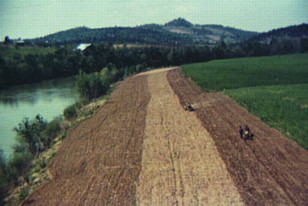
Photo by Marion Post Wolcott.
The moisture in the soil of this northern Tennessee
farm is connected to the water in the river and the water
vapour in the air through the hydrologic cycle. Because of
this connection, soil moisture not only affects crops directly,
but also indirectly by its impact on weather. Data from NASA's
Aqua satellite will keep farmers informed about both the direct
and indirect effects of soil moisture.
|
Farmers will be able to use the data
and the potentially improved long-range weather forecasts to help
plan growing seasons, schedule crop irrigation, prevent excessive
fertiliser use, and predict plant strength and resistance. Data
and forecasts will also be useful to water resource managers and
they will help agriculture officials estimate crop productivity.
"When the soil is dry, there is less
water for plant nutrition -- but there is also less evaporation,
and drier soil heats up faster," Crosson says. "There is a direct
link between soil moisture and atmospheric humidity. Both humidity
and rising heated air affect local and regional temperatures and
winds."
Crosson believes the data could be
especially helpful to large agribusiness operations where farmers
cannot easily obtain accurate long-term soil moisture data for fields
covering hundreds of square kilometres.
Until recently, environment and climate
measurements were either on a small scale involving ground-based
readings on fields less than one kilometre square -- or they looked
at huge areas of oceans and continents from space. Now scientists
will attempt to fill in the void for local areas and regional zones
with more diverse and accurate remote sensing techniques, says Charles
Laymon, another USRA scientist working on the project.
"Any farmer can stick his finger in
the soil to measure soil moisture, but there is no global context
in that," Crosson notes. "He doesn't know the large scale moisture
patterns that influence the future weather for his fields. A wet
patch in one corner of a field, or a dried-out hilltop, reveals
little about the farm's imminent crop productivity -- especially
if he's farming thousands of acres."
|
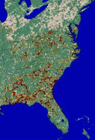
This Earth
Observation System integrated data image prepared by
the University of Montana School of Forestry is part
of the Upper Midwest Aerospace Consortium (UMAC) Surface
Moisture Index. Note the extreme soil moisture stress
(dark orange) in the drought-stricken southeastern U.S.
|
|
|
The instrument on Aqua that will sense
soil moisture is called the Advanced Microwave Scanning Radiometer-EOS
(AMSR-E, called "amser"). The Aqua satellite -- the second in a
series of satellites called NASA's Earth Observing System will have
an orbit that covers the globe every 16 days during a planned six-year
mission life. AMSR-E's moving "footprint" will be about 25-by-25-kilometres.
The deployment of AMSR-E will mark
a bold step in applied soil moisture research. Other past and present
space-based instruments obtained some soil moisture data, but were
not specifically designed for that purpose. Crosson and Laymon say
that what was once a practice of "using the wrong tool for the right
task" is now being replaced with designed and targeted observations.
"Putting microwave scanning radiometer
technology to use in the Earth Observing System is an important
step for soil hydrology," concludes Laymon. "Combining the diverse
long-term daily observations of land, oceans and atmosphere by EOS
will produce knowledge that ultimately improves everyone's quality
of life by improving the way we use the natural resources and systems
of our Spaceship Earth."
Hydrology as a science deals with the
properties, distribution and circulation of water on and below the
Earth's surface and in the atmosphere. Soil moisture is a key factor
in many climate processes, so it has long been of interest to hydrologists,
soil scientists, ecologists and meteorologists.
The effects of soil moisture are most
significant during warmer weather, Crosson says, whereas the dominant
factor in cold seasons is stronger, fast moving storms.
"The warm season is characterised by
stagnant, slower moving weather systems," Crosson explains, "and
when weather is relatively static for many weeks, subtle factors
and effects such as very dry or wet soil can play a larger role
in the weather patterns."
Summer conditions are heavily dependent
on springtime soil wetness, as that moisture eventually translates
into humidity. Low spring moisture in recent years has too often
left farmers woefully unprepared for ensuing summer and fall drought
conditions.
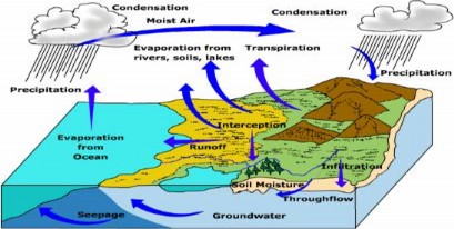
Graphic courtesy Michael Ritter, Univ. of Wisconsin
at Stevens Point.
The
hydrologic cycle, or water cycle, is the sum of the movement
of water through the Earth system. Because the water can carry
stored heat, it is a cycle of energy as well.
|
Crosson, Laymon and their NASA colleagues
hope that evaluations of remote-sensing data from current and future
space-based instruments will enable better farm productivity with
fewer losses from droughts and crop failures.
|