|
Little by
little, lightning sensors in space are revealing the inner workings
of severe storms. Scientists hope to use the technique to improve
forecasts of deadly weather.
by Annie
Strickler.
For most people
watching a thunderstorm roll in, the bolts of lightning are just
streaks of white light setting the night on fire, ushering in the
crackle and rumble of thunder. But these brilliant flashes of lightning
- electrical discharges between the positive and negative regions
of a thunderstorm - also illuminate the workings of the atmosphere,
providing information about storms that can improve emergency response
efforts, saving money and lives.
To harness this
information, NASA utilizes a fleet of ground-based, airborne and
space-based sensors to detect lightning and characterize the electrical
behavior of storms - all in the pursuit of advances in climatology
and "nowcasting."
More accurate
and timely forecasting, or "nowcasting," would help people gauge
evacuation measures, help aviation officials map routes and plan
refueling operations, provide better storm tracking, prevent systems
disruptions and minimize hazards to NASA's spacecraft launches.
Another potential benefit is providing algorithms for forecasting
the likelihood of forest fires.
"Incremental
gains ... really translate into cost and life benefits," says Dr.
Dennis Boccippio, an atmospheric scientist at NASA's Marshall Space
Flight Center in Huntsville, Ala.
 NASA
NASA
The
awesome power of nature.
|
Current ground
observations require about five minutes to scan a storm and make
a report on its characteristics. But, says Boccippio, "there's a
lot of evolution that can go on in a storm within that five minutes."
And infrared satellite observations - from which we get those famous
hurricane tracking reports that dominate television weather coverage
in the late summer and early fall - can take 20 to 30 minutes to
scan the "disk" of the Earth that's visible to the satellite. As
Boccippio says, and as many storm victims probably agree, "You pay
the price for that." Updating lightning flash rates at one-minute
intervals would benefit "nowcasting" efforts, according to Boccippio.
To this end,
a collective goal of researchers under the lead of Dr. Hugh Christian
at NASA and the Global Hydrology and Climate Center (GHCC) in Huntsville,
Ala., is to place a lightning sensor in geosynchronous orbit so
that scientists can monitor storms over their entire life cycles.
This sensor, called the Lightning Mapper Sensor (LMS), "would essentially
rotate with the Earth," giving it a constant view of storms, Boccippio
says.
"The end applications
goal," says Boccippio, "is to improve real-time forecasting. ...
It is the rapid updates that forecasters are excited about."
Measuring lightning
from space is relatively simple and inexpensive. The satellites
have some fancy optics, but Boccippio says they are "essentially
glorified digital video cameras."
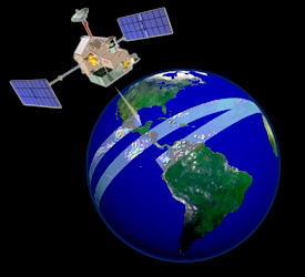
NASA
NASA's
Tropical Rainfall Measuring Mission (TRMM) satellite scans
the tropics, taking rainfall and lightning measurements.
|
One of their
unique characteristics is the ability to detect lightning during
the day when the human eye cannot sense it. Furthermore, because
of lightning's "impulsive, event-based" nature, the data sets are
relatively small in size. The promise is that the data will be easier
to deal with and to distribute to users.
The Lightning
Team has already successfully developed and flown two optical lightning
detectors. The first was the Optical Transient Detector (OTD). This
"large-scale climatology instrument" collected a five-year record
of lightning observations between April 1995 and April 2000.
The Tropical
Rainfall Measuring Mission (TRMM) was launched in November 1997
and has been providing high-resolution images and rainfall measurements
for the tropics between roughly 35 degrees north and south latitudes.
TRMM carries five unique sensory instruments, including the Lightning
Imaging Sensor (LIS) that enables scientists to study the distribution
and variability of global lightning.
Boccippio and
Goodman work at the National Space Science and Technology Center
in Huntsville, Ala., as part of the Lightning Team. Cummins - from
Global Atmospherics, Inc. - represents the commercial side of the
investigation. The company operates the National Lightning Detection
Network (NLDN), a network of about 130 time-of-arrival and magnetic
direction finders covering the United States.
The Monthly
Weather Review paper is based on four years of observations from
OTD and NLDN. The authors feel that while significant research has
been dedicated to variations in lightning flash rates, there has
been a dearth of research on the relative proportions of intracloud
and cloud-to-ground lightning.
 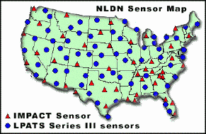 NASA
NASA
At
least 130 time-of-arrival and magnetic direction finders,
as shown in the image on the left, are positioned all over
the U.S. to locate lightning strikes. Each sensor can detect
the direction of a strike that's 400+ kilometers away. The
strike's location is determined by triangulation.
|
The ratio of
intracloud to cloud-to-ground lightning can help scientists detect
and interpret anomalies in severe storms. Intracloud lightning is
the most common and appears as channels of light emanating from
a central point. Cloud-to-ground lightning is less common but more
dangerous. The former type of lightning is weaker and harder to
measure over long distances, while the latter is easier to measure
from the ground. Global-scale measurement of both types is easier
from space.
The ratio between
the two types of lightning varies from storm to storm. In the past,
it has been difficult to get a baseline for that ratio. As evidenced
by this paper, merging satellite and ground measurements establishes
an average that enables scientists to identify an anomalous ratio,
or "one that is much higher than the garden variety," as Boccippio
put it.
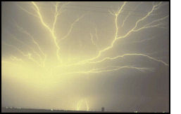
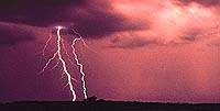
NASA
Both
intracloud and cloud-to-ground lightning are visible in this
photograph. (The cloud-to-ground strike is in the bottom center
of the image.)
|
The scientists
found that, in the Midwest and the Great Plains, storms were more
severe on average, and the ratio leaned toward intracloud lightning.
In the South, where storms tend to be less severe than they are
in the Midwest, there was a lower intracloud to cloud-to-ground
lightning ratio. The long-term average in the Southeast turned out
to be 3:1, while in the Midwest it was 10:1 on average and much
higher during severe storms. One of their key scientific findings,
Boccippio says, was determining "an average for the U.S….and finding
that there was significant variability by region."
While this may
not constitute a shattering of paradigms, their work is a step toward
NASA's goal of advancing climatology and real-time storm "nowcasting."
However, Boccippio notes that there are still "basic unanswered
questions [that] need to be tackled."
|