|
The rich diversity of wildlife in southern
Mexico and Central America is in peril. Local governments are using
satellites to get a grip on a vast "corridor" system of protected
lands.
by Patrick Barry
Central America is
on fire.
In
an area of rich bio diversity, where 7% of our planet's terrestrial
species are packed onto less than 1% of the planet's land, a rapidly
growing human population is struggling with widespread poverty that
affects more than 20 million people. Many of these people survive
through unsustainable "slash and burn" agriculture, putting themselves
and the rain forest on a collision course with catastrophe.
Simultaneously
promoting the local economy while protecting forests and wildlife
is the ambitious goal of an international project called the Mesoamerican
Biological Corridor (CBM is the acronym for the name in Spanish).
The
largest "sustainable development" effort of its kind in the world,
the CBM is a sprawling web of protected and semi-protected lands
that stretch the entire length of Central America from southern
Mexico to the border of South America - a region known as "Mesoamerica."
The lands of the CBM are collectively managed by the governments
of the seven Central American countries and Mexico. Together, these
governments preserve some areas of the CBM and in others promote
limited, "sustainable" economic use of the land.
"The
human dimension is now one of the most important factors for not
only conservation but also sustainable economic development," says
Daniel Irwin, a research scientist who has worked and lived in Central
America much of his life.
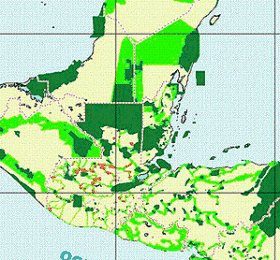
Image courtesy CBM.
This
map of the Mesoamerican Biological Corridor shows the
same region pictured in the satellite photo above. Dark
green denotes protected areas; light green denotes connecting
corridors. Red areas are proposed protected areas
|
"It's
not just a matter of fencing off animals and keeping it separate,
because there are so many people who live in the region," Irwin
says.
Sustainable
development is a relatively new direction in environmental thinking.
It acknowledges that people need to use nature's resources to survive,
but it also asserts that people must do so in an ecologically sensitive
way, or else those resources may not be there for future generations.
For
example, farmers might be encouraged to enrich the nitrogen in their
existing fields by planting legumes such as alfalfa, rather than
cutting and burning more forest when the soil becomes depleted.
Another popular approach is to use tax incentives to motivate a
land owner to set aside some of the forest on their property rather
than developing it.
To
maximize the ecological benefit of saving these forests, the CBM
maintains strips of land connecting the forested areas - another
relatively new idea in wildlife conservation called "corridors."
Animals
and plant seeds can then move between the areas, reducing the threat
of inbreeding or local disasters wiping out a species. And they
provide more space for top carnivores such as jaguars who range
long distances to survive. That's why the network of connected areas
as a whole has more ecological value than the sum of its parts.
"Because
you don't have intense migrations like in the African savannah,
your corridor can serve its purposes and still allow certain kinds
of human uses," explains Archie Carr III, a veteran conservationist
who leads the Wildlife Conservation Society's projects in the Caribbean.
Carr led a project between 1990-95 called the Paseo Pantera (Spanish
for "path of the panther") that originally established the corridor
system that later became the CBM.
Coffee,
for example, had traditionally been grown under the shade of trees.
This kind of coffee field mimics the structure of a natural forest
and thus provides good habitat for wildlife.
"Some
of this shade-grown coffee would provide corridor functions probably
perfectly well for an enormous number of tropical creatures," Carr
says.

Photo courtesy CBM.
People
and wildlife often live in close proximity in Central
America, and their needs sometimes conflict.
|
But
in modern times, a more productive, sun-tolerant strain of coffee
was introduced to the region, leading to treeless coffee fields
with little habitat for wildlife. Various organizations including
the CBM and the Rainforest Alliance are now trying to persuade coffee
farmers to return to the more ecological, shade-grown system.
It's
not easy for the region's environmental managers to keep an eye
on such a large area of land, though. That's why the intergovernmental
agency in charge of the corridor, called the Central American Commission
for Environment and Development (CCAD), has recruited the bird's-eye
view of NASA satellites to help out.
"The
landscape-wide perspective that satellites provide is essential
for doing a large-scale conservation project like this," Irwin says.
"The
rain forest is so thick in many places that you can hardly see 10
feet in front of your face," Irwin says. "Trying to survey such
large areas on foot is nearly impossible."
To
get the job done, Irwin and his colleagues use data from an assortment
of satellites. For assessments on the scale of entire countries,
they use data from the Moderate-resolution Imaging Spectrometer
(MODIS) on NASA's Terra and Aqua satellites. This sensor takes images
whose pixels each cover 250 meters of ground, suitable for looking
at such large scales. Landsat, on the other hand, has a resolution
of 30 meters, and is more useful for closer looks.
NASA
signed an agreement with CCAD in 1998 to use its Earth-watching
satellites - called the Earth Observing System - to help the corridor
project. One outcome of this collaboration was a study using Landsat
data from the 1990s that showed that the corridor was indeed protecting
the forests. About 80% of forests inside the CBM still remained,
compared with only about 31% outside the corridor. And annual forest
clearing rates were 5.5 times higher outside the corridor than inside
(1.44% versus 0.26%).
With
help from the World Bank, the team also assembled an ecosystem
map for all of Mesoamerica. The first of its kind to cover the
entire region, this map shows in detail where the rain forests,
lowlands, and croplands all lie - an invaluable tool for those managing
the CBM.
These
managers use the satellite data in other ways as well. For example,
data from MODIS shows the location of burning fires in the entire
region in near real-time (as in the image at the top of this article).
So
far, however, the principal use of the satellite data has been as
a political tool, according to Jorge Cabrera, the CCAD official
in Central America handling the collaboration with NASA.
"In
the case of the fires in the Petén and Yucatan regions this year,
giving this information to the media succeeded in mobilizing
more political, institutional, and public interest in the magnitude
of the disaster," Cabrera said in an e-mail interview (translated
from Spanish).

This photo was taken in Petén,
Guatemala, by Daniel Irwin.
Slash-and-burn
agriculture destroys forests and wildlife.
|
In
December, NASA signed a new agreement with the CCAD and the World
Bank to continue the use of satellites for the corridor project,
and to look into an innovative new way of making the satellite data
available.
The
concept they're considering is a live "dashboard" showing the state
of the environment in Central America as seen by NASA satellites
in near real-time, just as the dials on a car dashboard show the
state of the car. A computing "pipeline" would be designed that
would automatically gather the latest data from the satellites,
process the raw data into a relevant and useful form, and present
this user-friendly information to the people who need it: Central
American politicians, civic leaders, and even local students.
"The
information would be available in a timely manner for the Central
American decision makers - the ministers, the people who are really
making the calls about the environment down there," Irwin says.
After
all, when the fires are ablaze, time is of the essence.
|