|
Scientists
hope to use lasers to provide higher quality snapshots of the winds
that travel the globe.
by Annie Strickler
Scientists at the Global Hydrology and Climate Centre are studying
a type of radar that uses laser light instead of microwaves to provide
high-quality snapshots of the winds that travel the globe. Knowing
the wind's speed and direction over large areas could help meteorologists
answer the riddle of tomorrow's weather further in advance, saving
lives and benefiting many areas of the world's economy -- particularly
air travel.
"Lidar," or Light Detection and Ranging,
is a technique that's been used for years to study the atmosphere
from the ground. But now researchers are touting the benefits of
lidar from space.
Dr. Michael
Kavaya, a scientist at the Global Hydrology and Climate Centre (GHCC)
in Huntsville, USA, champions space-based laser sensing of the Earth's
winds because of the "immediate benefit of wind sensors orbiting the
Earth."
"Orbiting wind sensors could help airline pilots avoid headwinds,
leading to savings on fuel," explains Kavaya. According to one study,
these savings could amount to $100 million to $200 million per year
for airlines.
Fuel savings just scratch the surface of what lidar can accomplish.
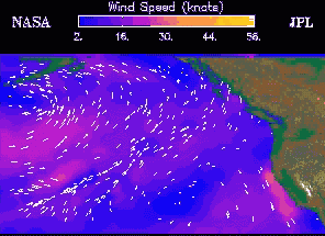
Graphic showing sea-surface wind speeds
|
"On-board lidar
sensors on each airplane would be valuable for microburst wind shear
and clear-air turbulence warnings. These are significant threats
to passengers' safety," says Kavaya.
"Clear air turbulence occasionally hurts people and even kills them.
There have been a few deaths in the past couple of years - people
don't have their seat belts on and they're thrown into the ceiling,
or the food cart is thrown at them. Microburst wind shears can cause
accidents on landing or take off "
Lidar may also prove invaluable for monitoring the flow of water
through rivers, for improving weather forecasts, and even for understanding
the complex El Niño/La Niña phenomenon.
Light Detection and Ranging
Lidar works by beaming pulses of laser light through the atmosphere
and detecting the light reflected back by dust and other small particles
in the air, called aerosols. The time between the pulse and the
echo determines the distance, and the shift in the colour of the
light determines the velocity of the particles along the laser's
line of sight. True wind speed and direction can be calculated from
these results.
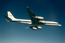
The Laser Radar (lidar) can fly on normal DC-8 Aircraft to
detect wind direction and speed.
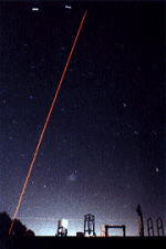
An
earth based lidar shooting up a sodium resonance beam over
the night sky of Puerto Rico.
|
If this sounds
a lot like Doppler radar, that's because it is. But there are some
important differences between the two technologies.
"Radar excels at piercing bad weather, but it needs raindrops or
hydrometeors (hail or snow) to get a signal," Kavaya said. "Lidar
struggles to go through thick clouds or heavy rain, but it can get
you wind (measurements) in clear air, because it relies on aerosols."
The reason for this difference is the frequency of the radiation
that each technology uses. Both emit electromagnetic waves, but
while radar typically uses frequencies in the range of microwaves,
lidar uses higher frequencies in the visible or near-visible light
range. Higher frequency radiation (light) will be reflected by smaller
particles than lower frequency radiation (microwaves).
Lidar also emits a narrower beam than radar, which minimise interference
from ground clutter and improves the resolution of the data. The
disadvantage is that lidar has more trouble covering large areas
than does radar.
Rivers are fair game, too
The narrower beam opens up another possible application for
lidar: measuring water flow in rivers.
Scientists at the Marshall Space Flight Centre and the GHCC have
been working with the U.S. Geological Survey to see if lidar may
be able to replace the manual stream-flow measuring technique that
the USGS currently uses.
"It turns out that some of their standard methods for measuring
stream current involved an element of risk to personnel," said Dr.
Jeff Rothermel, a NASA scientist at the GHCC. "In fact, one USGS
employee lost his life in the line of duty while making measurements.
So there is an interest there to determine whether lidar can be
used to measure stream current."
Mounted either at the side of the stream or on a satellite in space,
a lidar system would measure the speed of the water's surface at
several points across the width of the river. Knowing the shape
of the river's bottom would allow the volume of water flowing in
the river to be calculated from those measurements.
"[In addition
to US rivers] I imagine that we could contribute to the study of
the Earth's hydrology greatly by having improved river flow (data)
worldwide," Kavaya said.
River flow
measurement is a newer application for lidar than wind measurement,
and it is only in the early stages of development.
"We've attempted to do a proof of concept experiment along the Tennessee
River," Rothermel said, "and so far the results are encouraging."
Lidar's Crystal
Ball
Predicting hazardous
or inclement weather could benefit many sectors of the US economy.
One study estimates savings of about $110 billion annually if reliable
weather forecasts could be extended to seven days in advance.
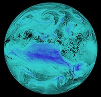
Image credit:NASA/Goddard
Water,
water, everywhere - but where does it go? This image of the
Earth depicts water vapour in the atmosphere.Predicting where
it will fall days ahead of time is a challenge for weather
researchers.
|
Scientists working
on lidar believe that a lidar-equipped satellite in a polar orbit
could bring about such an improvement in weather forecasting.
Why are wind measurements so important for weather forecasting?
"The wind carries heat, moisture, momentum, radiatively-active trace
gases, and aerosols," answers Rothermel. "The wind interacts with
clouds and radiation to produce weather and climate, and variations
thereof. Moreover, numerical model simulations indicate the addition
of new wind observations may improve forecasts more than the addition
of new temperature or humidity data."
Better wind data could also help refine mathematical models of large
scale weather patterns such as the El Niño-Southern Oscillation (ENSO).
"We need better wind information to measure how well we're doing or
how bad we're doing in modelling the [El Niño] situation," said Pete
Robertson, a scientist at the Global Hydrology and Climate Centre
in Huntsville, Alabama, who works on modelling ENSO.
Robertson noted that the patchy wind data provided by radiosondes,
ground stations, airplanes and cloud-watching satellites leave data
gaps in the tropics, which are particularly important for his research.
By helping "validate how the forecast model compares to reality,"
data from a satellite-based lidar system could allow Robertson's team
to improve their mathematical models of ENSO, which in turn could
improve medium-range forecasts -- those between seven and 10 days
in advance, Robertson said. On those time scales, pressure waves in
the air over the Pacific (where ENSO occurs) have time to spread to
the North American continent and affect US weather patterns.
More wind data may help extend weather forecasts, but Robertson cautioned
that there is a theoretical limit to how far into the future accurate
forecasts will ever be possible.
"No matter how good you know your initial conditions, there's a certain
amount of chaotic behaviour in the atmosphere," Robertson said. "So
... a really deterministic weather forecast is only going to be possible
for maybe up to two weeks."
Dr. James Keesling, a professor of mathematics at the University of
Florida who specialises in chaos theory, commented on this theoretical
limit.
"The lidar system may provide us with unprecedented detailed information
about the direction and intensity of winds throughout the globe,"
Keesling said. "However, we know that unless this data is perfect
and the computers using that data in their computations use an impossible
number of digits, we will not be able to predict very far into the
future. The problem is in the mathematics itself, not the accuracy
of the data."
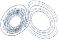
Chaos theory predicts
that systems such as the world's weather that involve chaotic behaviour
(in the mathematical sense of "chaotic") will exhibit a property sometimes
called the "butterfly effect." First identified by a meteorologist
named Edward Lorenz in 1963, the butterfly effect refers to a situation
when very small differences can lead to very large differences over
time. Hence the famous example of a butterfly flapping its wings in
New York City's Central Park and causing a tornado in Texas.
Lidar might not be able to sense the gentle breeze of a butterfly
in flight, but by forecasting storms and detecting turbulence the
technology could save millions of dollars and even human lives.
|