|
By Patrick
L. Barry
Scientists are
using two orbiting research satellites to peer into the centre of
storms in ways that were never before possible, in a bid to understand
what happens at the heart of a hurricane. Unlike most weather satellites
that can only take pictures of a hurricane's cloud tops, NASA's QuikScat
and Tropical Rainfall Measurement Mission (TRMM) satellites carry
microwave sensors that can "see" through the clouds and scrutinise
conditions -- including rainfall, wind and water temperature -- at
the ocean's surface. This data could allow researchers to detect tropical
depressions earlier and to predict where hurricanes are headed with
greater accuracy.
"I think the
rain and the wind together is a very powerful tool to study hurricanes,"
said Dr. Timothy Liu, project scientist for the QuikScat mission
at NASA's Jet Propulsion Laboratory.
QuikScat, which
was launched in June 1999, uses an instrument called a "radar scatterometer"
to measure both the speed and the direction of surface winds over
the world's oceans.
Other radar-based
satellites can measure wind speed, Liu said, but "the only thing
that can measure the wind vector -- that is, the speed and the direction
together -- is the scatterometer."
A scatterometer
works by sending a beam of microwave radiation toward the ocean
surface at an angle. The beam, which passes undisturbed through
clouds, gets scattered by the ocean surface, and some of the microwaves
bounce back toward the satellite. A rougher ocean surface,
which indicates higher winds, will reflect more radiation back toward
the satellite than a smooth surface will.
Liu and Dr.
Kristina Katsaros of NOAA found that the wind data from QuikScat
could be used to identify potential hurricanes one to three days
before traditional methods.
Part of the
reason for this, Liu said, is that the satellite photographs used
by the National Hurricane Centre show only the cloud tops of forming
hurricanes, which sometimes can be obscured from view by higher
clouds.
Another key
to understanding and predicting hurricanes is rainfall. Rainfall
snapshots are produced by the TRMM (Tropical Rainfall Measuring
Mission) satellite, which is a joint mission between NASA and the
National Space Development Agency (NASDA) of Japan.
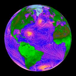
Courtesy JPL
A
snapshot of the speed and direction of ocean surface winds
taken by QuikScat. Pink and yellow represent high velocity
winds, and purple and blue represent slower winds. The
white lines and arrows indicate direction.
|
"The big impact
that the rainfall data can have is that the rainfall in these tropical
storms are signatures of the amount of latent heat that's being
released into the atmosphere," said Dr. Marshall Shepherd, a research
meteorologist at NASA's Goddard Space Flight Centre
Incorporating
rainfall data from TRMM into computer weather models "gives the
model a better handle on the energetics that are required to drive
the circulation, to drive the hurricane and also affect its path,"
Shepherd said.
The TRMM satellite
can also use its microwave sensors to measure ocean surface temperatures
beneath a hurricane.
"Hurricanes
are intimately tied to the sea surface temperature," Shepherd said. "There's
generally kind of a threshold temperature (above which) hurricanes
like to form. If you have all of the other a priori
conditions in place, and if you have ample warm sea surface temperature
and moisture, then you can get a hurricane that likes to grow,"
Shepherd said.
Higher sea surface
temperatures mean more evaporation of ocean water into the air. As
that moisture condenses into clouds, it releases heat to the air
that causes the air to rise. The rising air creates a low pressure
area beneath it that pulls the surrounding air spiralling inward,
perpetuating the hurricane.
"It's that conversion
of latent heating that's carried from the water vapour when it condenses
to form the clouds in the hurricane -- that's really the fuel supply
that powers the hurricane engine,'" Shepherd said. "We tend
to think of hurricanes as big heat engines."
Low sea surface
temperatures can spell death for a hurricane, as in 1998 when the
"wake" of cold water behind Hurricane Bonnie caused Hurricane Danielle,
which was following close behind, to dissipate.
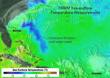
(TMI)
sea-surface temperatures - Blues represent cooler water, greens
and yellows are warmer water. TMI is the first satellite microwave
sensor capable of accurately measuring sea surface temperature
through clouds.
|
Traditional
weather satellites that use infrared sensors can also measure sea
surface temperature, but "the big advantage that the TRMM microwave
imager has ... is that microwave instruments can see through clouds,
whereas infrared instruments (on traditional weather satellites)
can only give you sea surface temperatures in clear regions," Shepherd
said.
While the kind
of rainfall and sea surface temperature data produced by TRMM holds
great potential for improving hurricane forecasting, TRMM is not
primarily a hurricane-monitoring satellite.
"Things like hurricane monitoring ... are extra benefits of the satellite,
but its main mission is to measure rainfall," Shepherd said. "TRMM
is a research mission -- it wasn't designed to be used in an operational
setting.
"But where the
data can be used, I'm sure it is ...."
|