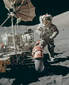
|
NASA plans to put a laser in orbit
around the Moon to map its surface for future explorers.
by Patrick L Barry
Imagine trekking in
a lunar rover across miles of the Moon's rough surface. Your mission:
to explore a crater with suspected deposits of ice.
In every direction,
the gray terrain looks more or less the same. Wouldn't want
to get lost in this place! you think to yourself. You arrive
where the rover's digital map says the crater should be ... but
it's not there!
In a flash, you realize
that your map is wrong. The crater's true position must be slightly
different. But how different? A kilometer? Ten kilometers? In which
direction?
Mission aborted.
The story is fiction,
but it raises a real-life issue: the need for accurate maps of the
Moon's terrain.
When
travelling on the Moon, don't forget your map!
|
According to NASA's
Vision
for Space Exploration, astronauts will return to the Moon as
early as 2015. This is a key step en route to Mars and beyond. On
the Moon, which is practically in Earth's backyard, astronauts can
learn how to live on an alien world before attempting longer voyages
to other planets.
However, our current
maps of the Moon are not very precise. In some areas, near Apollo
landing sites, for instance, the locations of craters and ridges
are well known. They were extensively photographed by lunar orbiters
and Apollo astronauts. But much of the lunar surface is known only
approximately.
"If you ask 'where
is a crater on the far side of the Moon?', chances are there's probably
many kilometers of uncertainty in its true positioning," says
David Smith, a scientist at NASA's Goddard Space Flight Center.
Even on the near side of the Moon, Smith adds, errors in the true
global position of features may be as large as a kilometer.
To improve this situation,
NASA plans to send a high-precision laser altimeter to orbit the
Moon and create a 3-dimensional map of its surface. When completed,
the map will be so accurate that we'll know the contours of the
Moon better than we do some remote regions on Earth. Astronauts
will be able to use it like a USGS hiking map.
The laser is named
"LOLA," short for Lunar Orbiter Laser Altimeter. It's
scheduled to launch in 2008 onboard the Lunar Reconnaissance Orbiter
spacecraft. LOLA works by bouncing pulses of laser light off the
lunar surface as it orbits the Moon. By measuring the time it takes
for light to travel to the surface and back, LOLA can calculate
the roundtrip distance. LOLA is capable of timing pulses with a
precision of 0.6 nanoseconds, corresponding to a distance error
of no more than 10 cm.

A
3D map of the martian volcano Olympus Mons, produced in
the late 1990s by MOLA--the Mars Orbiter Laser Altimeter.
LOLA, a close relative of MOLA, will produce similar views
of the Moon.
|
"In a sense, the Moon is an ideal
object for making these kinds of observations because it has no
atmosphere to interfere with the propagation of the laser pulses,"
says Smith, who is the Principal Investigator for LOLA.
LOLA will map the Moon
for at least a year, orbiting from the Moon's north pole to the
south pole and back every 113 minutes. As it orbits, LOLA will send
out laser pulses 28 times per second. Each pulse consists of 5 laser
spots in a cross-like pattern spanning about 50 meters of lunar
surface. Altogether, LOLA will gather more than 4 billion measurements
of the Moon's surface altitude.
After taking into account
uncertainties in LOLA's orbit, the overall error in the true elevation
of lunar features should be no more than a meter, while the true
horizontal locations of those features should be known to within
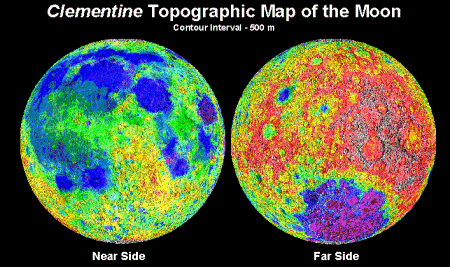
50 m or less. The next-best laser ranging map, made by the Clementine
mission in 1994, had an error of 100 m vertically and a horizontal
resolution as coarse as 30 km.
This new map, combined
with high-resolution images of the lunar surface taken by a camera
onboard the spacecraft, will offer by far the best 3-dimensional
model of the Moon ever created.
Uses abound.
"A detailed knowledge
of the shape of the Moon, how and where it diverges from a perfect
sphere, can tell us a lot about how the Moon formed," notes
Smith.
more
A
map of the Moon's surface based on Clementine's laser
altimeter. LOLA will produce a far superior 3-D map of
the Moon.
|
It'll make a great
video game, too. Imagine flying around a photorealistic 3-D moonscape,
over hills, in and out of craters, around Apollo landing sites.
Astronaut training, anyone?
For people actually
living on the Moon, LOLA-style maps will be indispensable. Imagine
getting caught outside, moonwalking, during a solar flare. Check
your LOLA map for the nearest cave: instant shelter. Disoriented
by moondust? LOLA has your bearings.
Misplaced a crater?
Unimaginable.
|