|
Scientists are learning that the key to predicting
certain epidemics - like Rift Valley fever in Africa or Hanta virus
in the U.S. - lies in an unexpected place: the ocean.
by Karen Miller
On the dusty savannahs of
eastern Africa, where livestock sustain the economy, about twice a
decade an epidemic whips through to decimate the herds. Nearly all
of the pregnant animals spontaneously lose their fetuses. Among those
already born - the lambs and kids - the mortality rate can reach 90
percent.
It's called Rift Valley fever.
Humans can be infected as well, either through
mosquitoes that carry the disease, or by handling infected tissue.
Few die, but the illness can cause serious complications: meningoencephalitis,
an inflammation of the brain, and lesions of the retina, which leave
victims with at least some permanent loss of vision. During the
most recent and devastating outbreak in 1997-98, an embargo banned
exports of East African meat for one and a half years.
While no easy treatment exists for the
disease, Rift Valley fever can be controlled. Animals can be vaccinated,
insecticides can be spread into the soil to keep infected mosquitoes
from hatching. But the disease's unpredictability has been a sticking
point: without knowing when and where the disease will strike, it's
hard to know how to use those controls efficiently.
more
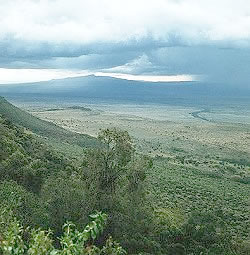
Rift Valley fever was first identified
during the 1930's when it struck residents of Kenya's great
Rift Valley, pictured here.
|
But the disease might
not be so capricious after all, says Assaf Anyamba of NASA's Goddard
Space Flight Centre.
Anyamba and colleagues
at Goddard and at the Walter Reed Army Institute of Research have
discovered that outbreaks of Rift Valley fever follow sudden floods
triggered by El Niño and a similar (yet lesser-known) climate disturbance
called the "Indian
Ocean Dipole." Using
weather satellites to track sea surface temperature patterns in
the Indian and Pacific oceans, they now believe they have found
a way to predict outbreaks up to five months in advance.
Sea surface temperatures can predict the likelihood
of the disease because tiny variations in these temperatures cause
huge shifts in air circulation patterns - shifts that alter rainfall
around the globe. El Niño, for example, happens when a
band of warmer-than-average water forms near the Pacific coast of
South America. Meanwhile, Pacific waters near Australia and Indonesia
become a bit cooler than usual.
A similar type of temperature imbalance can
occur in the Indian Ocean, with the western part near Africa becoming
warmer than the eastern part near Australia. Indeed, researchers
liken this "Indian Ocean Dipole" to El Niño in the Pacific. Both tend to
increase rainfall in East Africa.
When the two anomalies occur at the same time,
buckets pour.
more
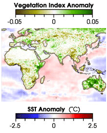
This map shows the greening of East
Africa during an Indian Ocean warm spell in 1983.
|
"The year 1997 saw the largest El Niño ever
recorded simultaneous with a very large Indian Ocean Dipole (see
figure)," says Christina Clark, an atmospheric scientist at the
University of Colorado. "East African rainfall was then the highest
on record, in many places five times the normal amount." Such floods
bring Rift Valley fever because water collects in shallow depressions
called "dambos" that punctuate the savannahs, providing mosquito
eggs with exactly the nurturing conditions that they need to hatch.
The data about both sea surface temperature
and vegetation is provided by NOAA's Advanced Very High-Resolution
Radiometer (AVHRR) - a type of visible-light and infrared sensor
carried on many polar orbiting weather satellites. "These satellites
were not really designed to monitor land surface conditions," says
Anyamba. "They were designed to monitor atmospheric conditions -
basically, clouds." But Goddard scientist Compton Tucker realized,
says Anyamba, that by manipulating the information provided by the
AVHRR, he could produce a 'greenness index,' which measured the
condition of the vegetation on the ground.
Using sea surface temperatures to predict when
East Africa might be vulnerable, and using the greenness index to
pinpoint exactly where, researchers can alert health officials to
potential danger. "What we can do is provide public health officials
with an efficient way of being able to focus their resources, rather
than sending teams out all over the place," says Anyamba.
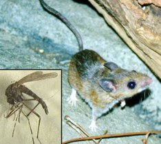
Deer
mice and mosquitoes are disease vectors that can suddenly flourish
in areas made wet by El Niño.
|
The method used to forecast Rift Valley fever
could be expanded to predict other types of epidemics. It could
be applied in areas that, like East Africa, are usually dry, but
sometimes experience heavy rains, and that, like East Africa, have
ecosystems that burgeon when precipitation comes.
Hanta virus outbreaks in the American southwest
could be monitored in this way. The virus is carried by deer mice
and can kill people who have been exposed to it. Like Rift Valley
fever, says Anyamba, Hanta virus is correlated with rainfall. "The
US southwest is really a very dry environment," he says, "and you
are likely to see there the same kind of bioclimatic rhythms that
you see in East Africa."
Right now, says Anyamba, "we're in operational
mode [for East Africa]." Every month, he and his colleagues post
their findings on the web, so that people in the field can "check
the animals, check the people, see whether there's any activity."
Things are quiet - for now.
But sea temperatures will shift again. And
when they do, the work of Anyamba and his colleagues will save lives
|